
District Overview
History of Bemetara District - According to the Gazetteer of Durg district, the entire Durg district, including Bemetra, was first included in the Emperor Ashoka’s empire. In 1742 AD, this region remained under the Marathas and from 1853 to Bhosale Raja. It is said that in ancient times, this was the kingdom of the queen named Vyomtara, after which the name of this city was named Bemetara. Later on this land customs came into force. Jarab Singh Verma, the last landowner of this from 1857 to 1906, the entire Durg was included in Tahsil Raipur district. Bemetra was under Simga tahsil and Navagarh area was in Bilaspur district. When Durg was formed in 1906 AD, Bemetara was main tehsil in three tehsils of the district. From the earliest times, the Bemetara tahsil included Navagarh, Berla and Saja blocks which is also in the newly formed Bemetara district since 1 January 2012.
• :
Demography :
According to the 2011 census Bemetara district has a population of . And The district has a population density of inhabitants per square kilometer . Its population growth rate over the decade 2001-2011 was %. Bemetara has a sex ratio of females for every males, and a literacy rate of %.
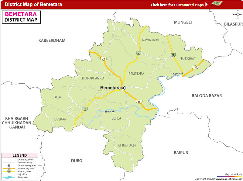 Map of District - Bemetara (C.G.)
Demography
According to the 2011 census Bemetara district has a population of . And The district has a population density of inhabitants per square kilometer . Its population growth rate over the decade 2001-2011 was %. Bemetara has a sex ratio of females for every males, and a literacy rate of %.
District Bemetara -:
| Name of the Geographical Unit | Detail of the Geographical Unit |
|---|---|
| District Formation date | 1 January 2012 |
| Position of Bemetara District | Situated on the northern side of Durg district and primarily in the west-central part of Chhattisgarh. |
| Latitude: | The district is situated between 20-23” North to 20-02” North latitude |
| Longitude: | The district is situated between 80-46” East to 81-58 East longitude |
| Height From Sea Level | 558 Meters |
| Temperature (Average): | Max – 30° Min – 17.6 ° (Year 2015) |
| Area | 2854.81 sq. km. |
| Forest Area | Sq km (Year-2022-23) |
| Climate | The Climate is ideal with a beautiful monsoon, a mild summer and a bearable Winter |
| Average Rainfall(June to Oct.) | mm ( Year-2012) |
| Surrounding Districts | The District is surrounded by seven districts, including Durg, Raipur, Balodabazar, Mungeli, Kawardha (Kabirdham), Rajnandgaon, and Khairagarh-Chhuikhadan-Gandai. |
| Name of the Organizational Unit | Detail of the Organizational Unit |
|---|---|
| Sub Division | 4 [Bemetara, Saja, Nawagarh and Berla ] |
| Tehsil | 9 [Bemetara, Berla, Saja, Thankhamhariya, Nawagarh, Nandghat, Bhimbhouri, Devkar, Dadhi ] |
| Sub Tehsil | 0 |
| Block/Janpad Panchayat | 4 [Bemetara, Saja, Nawagarh and Berla ] |
| Nagar Palika Parishad | 1 [Bemetara ] |
| Nagar Panchayat | 7 [ Devkar, Nawagarh, Saja, Berla, Maro, Parpodi and Thankhamhariya] |
| Gram Panchayat | 429 |
| Total Village | 702 |
| Populated Village | |
| Forest Village | |
| Deserted Village | |
| Revenue Inspector Circle | 09 |
| Patwari Halka | |
| Forest Division | [ ] |
| Police Station | 4 |
| Police Post | 2 |
| Particulars | Reference Year 2011 | Reference Year 2001 |
|---|---|---|
| Population | 7,95,759 | ( MCB included) |
| Male Population | 3,97,650 | ( MCB included) |
| Female Population | 3,98,109 | ( MCB included) |
| Population growth Rate(%) | ||
| Population Density (Per Sq Km) | ||
| female-Male Ratio(Every 1000) | ||
| Population of 0-6 Age Group | ( MCB included) | ( MCB included) |
| Percentage of 0-6 Age Group in Population | ||
| female-Male Ratio Age Group of 0-6 | ||
| Scheduled Caste | ( % of Total Population ) | ( % of Total Population )( MCB included) |
| Scheduled Caste female-Male Ratio | ||
| Scheduled Tribe | ( % of Total Population) | ( % of Total Population) ( MCB included) |
| Scheduled Tribe female-Male Ratio | ( MCB included) | |
| Literate | % | |
| Literate Male | % | % |
| Literate Female |
Back To Previous Page | Last updated:29-05-2026 05:00 pm